
Case Studies
Who: Multiple Agencies and NGOs in Alaska
What: Building New Hydrography and Virtual Watersheds to Conserve Freshwater Fisheries
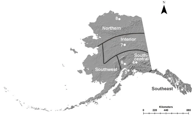
Where: Four regions in Alaska
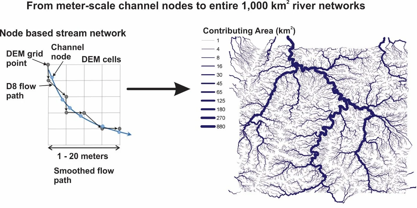
Increasing availability of high-resolution digital elevation data is enhancing the mapping of hydrography across Earth’s surface. Newly available radar and laser digital elevation products were used to discover thousands of kilometers of previously unmapped channels, ranging from headwater to valley bottom streams in Alaska. This comprehensive and attributed high-resolution hydrography that connects lentic, lotic, and terrestrial systems—a virtual watershed—has resulted in tens to hundreds of percent increases in identified salmonid habitats across landscapes ranging from the Arctic tundra to southeast rainforests. This long-term study is a model for supporting conservation efforts and environmental problem-solving in other regions globally.
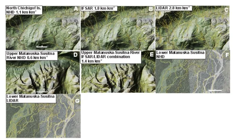
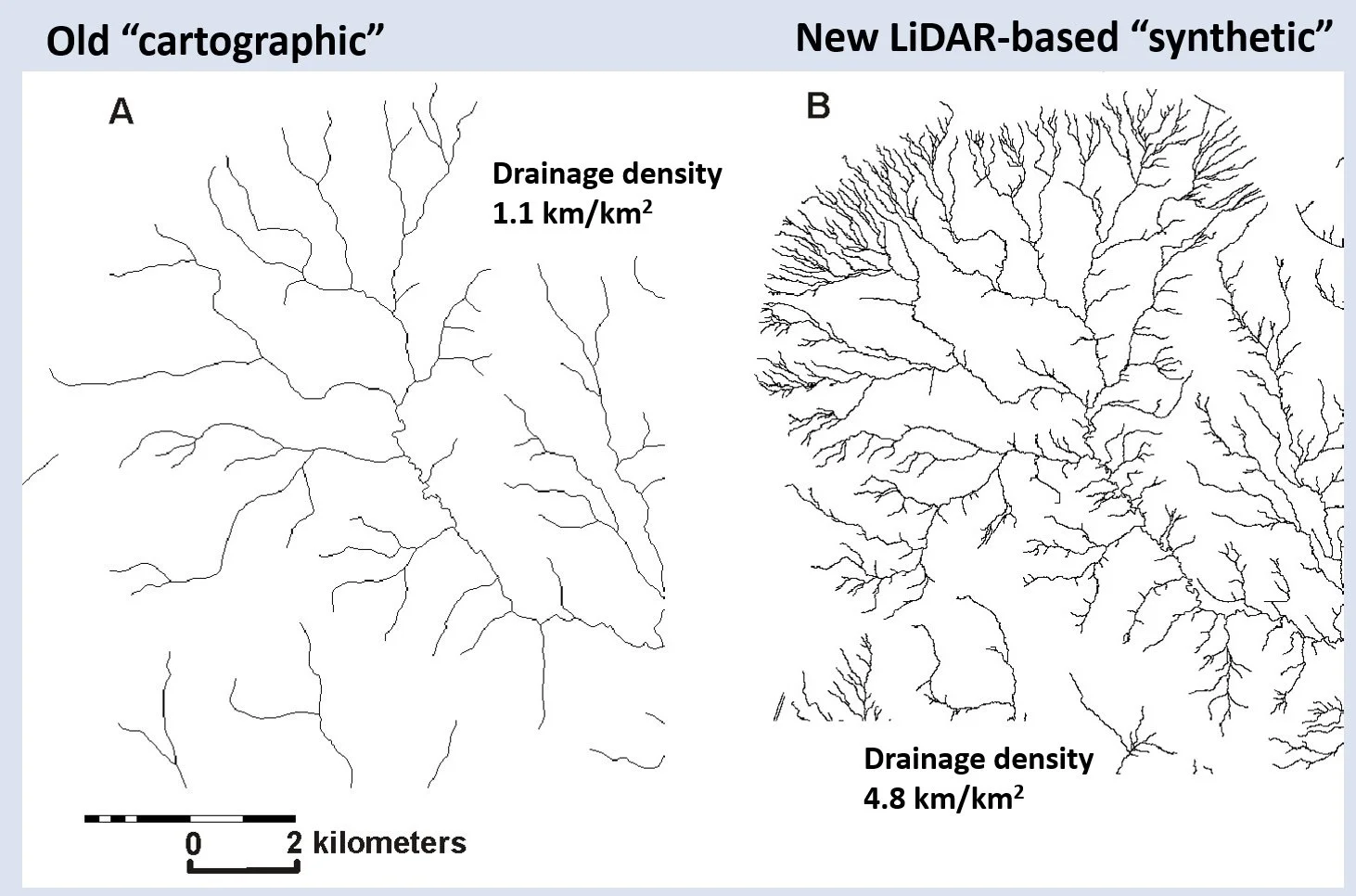
The density of channel networks in northern Chichagof Island in southeast Alaska increases from the cartographic NHD to the synthetic networks delineated from IFSAR and LiDAR DEMs (A-C). (Right panel) The increase in river network density is illustrated in the Matanuska-Susitna River watershed (D-E). The network delineated from the IFSAR/LiDAR combination occurs in both the upper valleys as headwater tributaries and along the wider valley floors with braided channels (F-G).

Predicted coho salmon habitat in the North Chichagof Island increased in the more densified channel networks that were delineated in IFSAR and LiDAR networks, compared to Alaska’s anadromous watershed catalog that is based on the cartographic NHD.
Who: State of Oregon
What: Building Smart Digital River Networks (NetMap) in Support of Habitat Conservation
Where: Entire State of Oregon
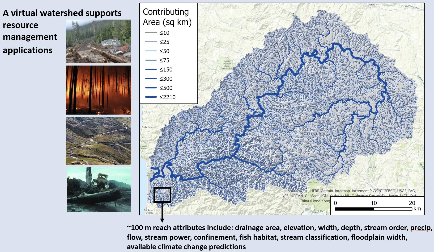
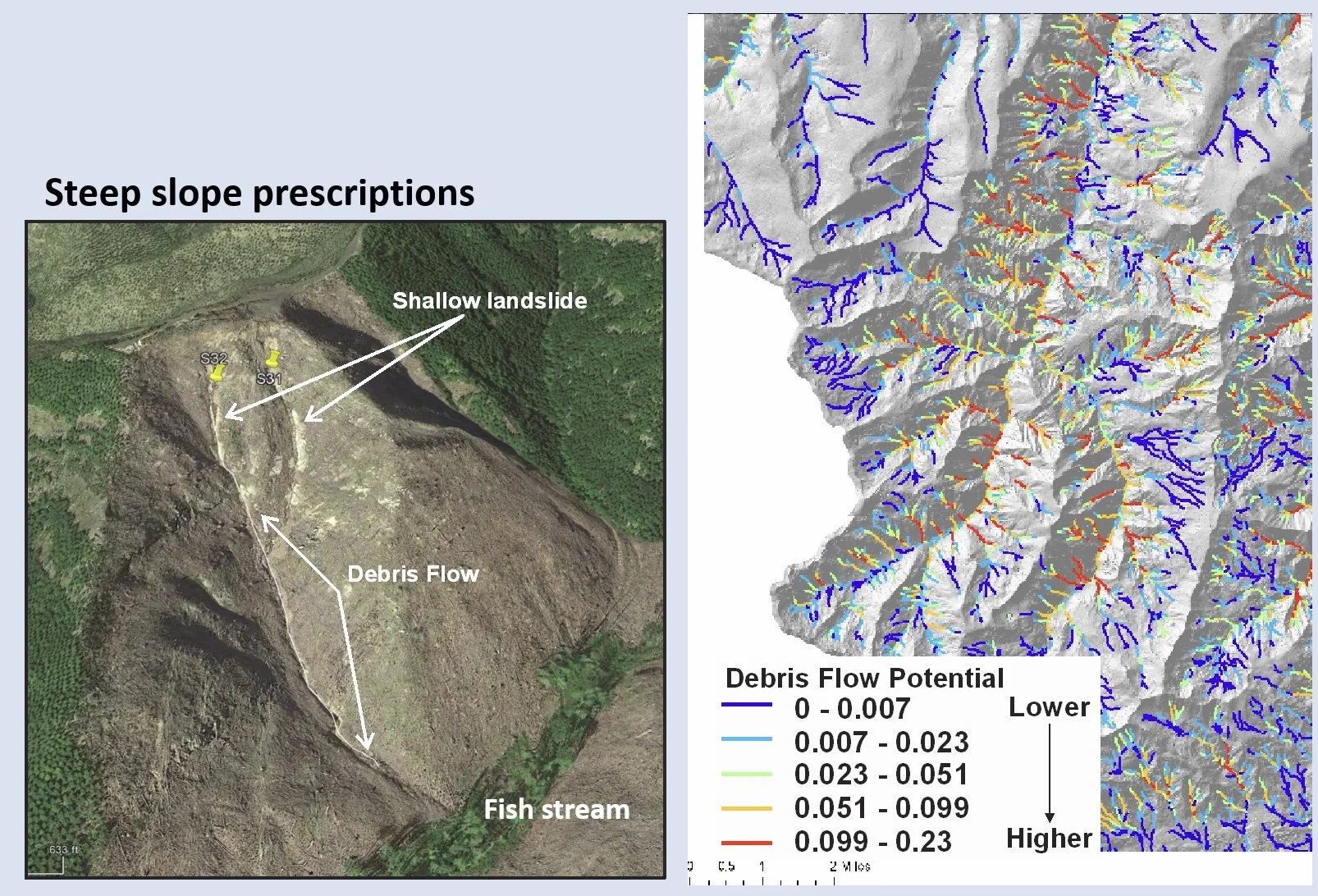
Terrainworks partnered with the State of Oregon (Oregon Department of Forestry) to develop new digital river networks using the most up-to-date digital elevation models (LiDAR) in support of the Private Forest Accord. The heavily attributed stream layers supported modeling of anadromous and resident fish habitats to aid in the design of new riparian management prescriptions. The NetMap virtual watersheds were also used to predict likely locations of landslides and debris flows, and where they may intersect fish habitats, in support of new steep slope prescriptions.

Who: Province of Alberta
What: Improved Mapping and Characterization of Riverine Landscapes in Alberta
Where: Alberta, Canada
Terrainworks partnered with the Fisheries Research Institute, and Canfor, Weyerhaeuser, and West Fraser timberland companies in development of new digital river networks across the Rocky Mountain foothill region of Alberta. Objectives of the new LiDAR-based hydrography include:
LiDAR DEMs merged into a continuous terrain elevation model
Continuous routed channel networks
Spurious road-channel diversions corrected
Stream reaches populated by watershed and channel features
Floodplains mapped
Creation and application of a channel regulatory classification system
Creation and application of a prototype fish habitat model

Who: NOAA-Fisheries, Watershed Councils, US Forest Service, Tribes, NGOs
What: Salmon-Related Watershed Restoration
Where: Oregon Coast Range
State and federal agencies, including NOAA-Fisheries, Dept. of Fish & Wildlife, Oregon Watershed Enhancement Board and US Forest Service, in cooperation with tribes and NGOs, are committed to restoring coho salmon habitats in watersheds along the Oregon Coast Range.
They are funding NetMap analyses of key watershed processes using LiDAR DEMs involving fish habitats, floodplains, riparian processes, landslide potential and forest roads.
Restoration Targets: In-Stream, Riparian, Forest Roads, Landslides
See an example analysis here.

Who: Federal & State Agencies, University, Private Sector
What: Advanced Resource Management and Research
Where: Alaska
Tongass and Chugach National Forests, US Geological Survey, The Nature Conservancy, Ecotrust, Fish & Wildlife Service, University of Alaska, The Wilderness Society and Sealaska are engaging TerrainWorks to build improved and functional synthetic river networks to support resource management, research, restoration and conservation across tens of millions of acres in Alaska, from Southeast to the Arctic.
Applications for improved synthetic river networks and NetMap’s Virtual watersheds in Alaska.
Who: Alberta Provincial Government
What: Management of Critical Freshwater Fishery Resources
Where: Rocky Mountain Foothills
Alberta Forest Management Branch, Foothills Research Institute, University of Alberta and West Fraser have contracted with TerrainWorks to build NetMap virtual watersheds to support forest road improvements in critical fish habitat watersheds and advanced forest management planning over millions of hectares.
NetMap’s forest road analysis identifies locations where new road drainage features and road surfacing (gravel) will maximize and optimize reductions in runoff and sediment delivery to critical fish habitats.

Advanced numerical modeling is applied to predict runoff and sediment delivery to streams.
Who: US Forest Service and State Partners
What: Post Wildfire Forest Management
Where: Los Padres and Angeles National Forests, So. California; Malheur National Forest, eastern Oregon
The National Fish & Wildlife Foundation in cooperation with the US Forest Service funded development of NetMap Virtual Watersheds and Smart Stream Layers to support post-wildfire forest management and watershed restoration in the Los Padres and Angeles National Forests. Watershed resources of interest included fish habitats, riparian zones, sediment pollution and forest roads.
Use of NetMap tools can identify which road segments in a burned watershed will have increased hydrologic connectivity.


