
Wildfire Planning
Following a wildfire, many watershed processes and features are impacted.
Impacts include threats to lives and property from landslides, debris flows and flash floods. Ecological impacts to riparian and aquatic systems also can occur.
Where does one go to prioritize post-fire restoration? Where is the largest potential for mass erosion and flash floods?
Which road segments pose the greatest threat, post fire?
Which channel segments are most at risk for habitat degradation?
Use NetMap tools to plan and prioritize post fire watershed restoration.
See Wildfire Tool Storymap
See Power of Virtual Watersheds in Post-Fire Planning in Oregon:
Clackamas River
Upper Rogue River

Start with a Burn Area Reflectance Classification Map or Similar

Import a BARC map into NetMap.
Using individual stream reach local contributing drainage areas (see Virtual Watershed), fire intensity values are transferred to channel reaches (as an attribute) and routed downstream, providing a fish-eye view of burn severity.


Wildfire can lead to a cascading sequence of events that can impact lives, properties and aquatic and riparian ecosystems.
NetMap is used to identify the potential for the cascading sequence of impacts.
We predict the potential for accelerated post-fire surface erosion and sediment delivery to streams using the USFS WEPP-Disturbed model.


WEPP surface erosion predictions are transferred to channel segments.
This allows spatial overlap between predicted post-fire erosion and sediment delivery with sensitive aquatic habitats.
Prioritize erosion control activities at hotspots that risk aquatic and water quality resources.
NetMap predicts the potential for gully erosion, post fire.
Use these predictions to help design salvage logging to reduce the potential for accelerated erosion.


The potential for shallow failures, post-fire, uses a topographic index that employs slope steepness, plan curvature and specific drainage area.
The potential for debris flows applies a topographic index that includes headwater channel steepness, valley confinement and variation in channel plan geometry.

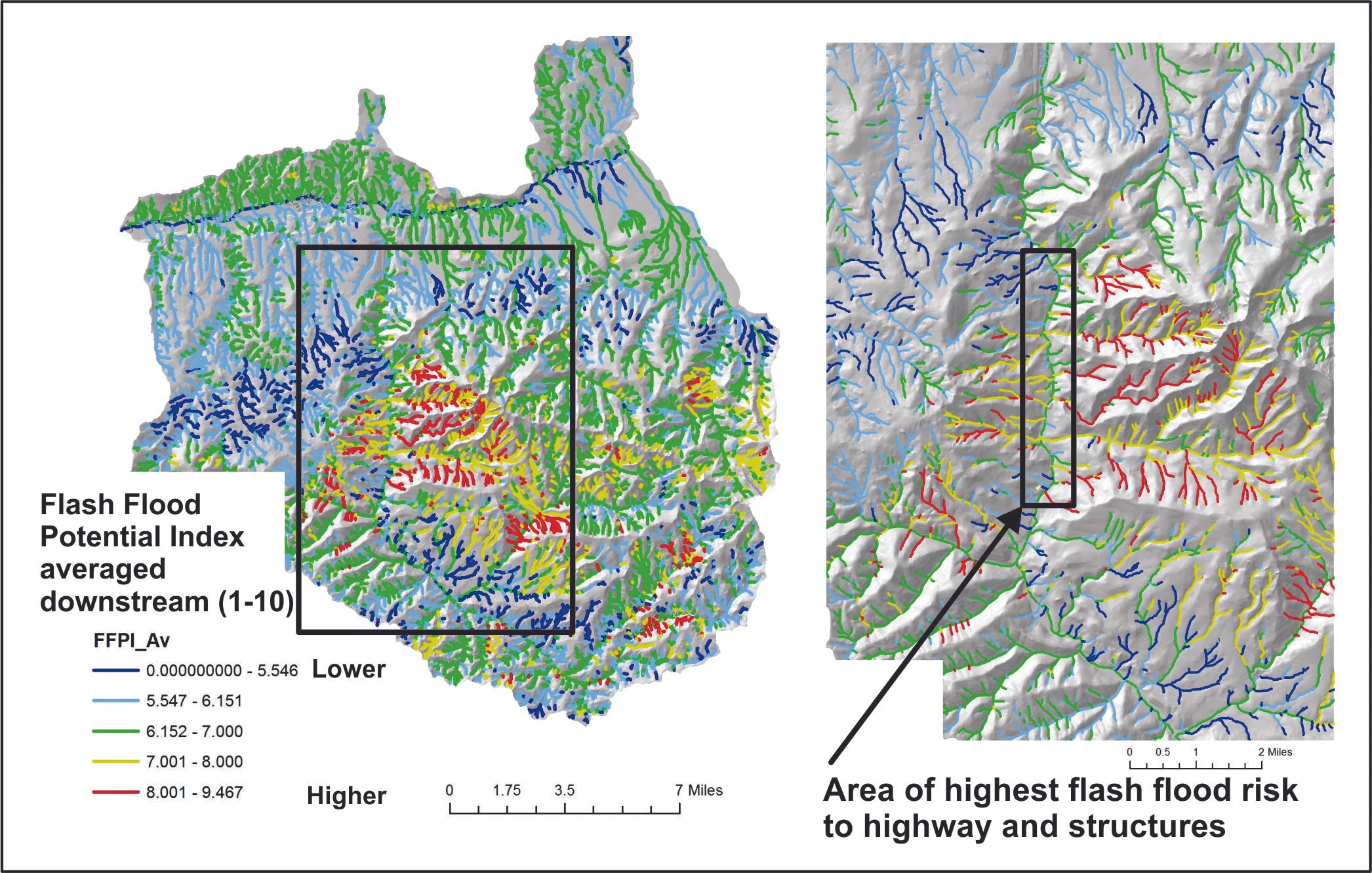
NetMap uses a National Weather Service Flash Flood Index model at the individual channel reach and tributary scales.


NetMap contains tools to identify critical overlaps of post-fire stressors and sensitive habitats.

Water repellant soils that occur post-fire can result in greater hydrologic connectivity between unpaved forest roads and stream channels.
NetMap’s READI model is used to identify which road segments are at greatest risk. This would support prioritizing road restoration activities like adding additional road drains and placement of erosion mitigation measures.